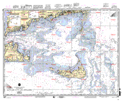
Boat Insurance Quote Home Advertise Contact Us Instant Quote Legal Use Privacy Policy
  • Boat Insurance
  • Boat Financing
  • Boat Resources

Nautical Charts

The most essential tool available to a boater is a navigational chart. A navigational chart displays the marine environment similar to a road map and is important for safe navigation. They often contain information on buoys and beacons, lighthouses, radio and weather stations, shipping channels, and restricted areas. Also water depths are recorded as soundings, in meters, feet or fathoms. Near shore depths are shown by contours and layered tints. Physical features such as shorelines, shallows, reefs submerged rocks, shipwrecks, kelp beds, ocean bottom sediments, are all shown in detail.
Where to find Nautical Charts
Nauticalcharts.com
A broad selection of navigational charts, books, and guides for recreational and professional mariners. Simple "Click" selection and ordering lets you order quickly and accurately.
NOAA Nautical Charts
NOAA's Nautical Chart products
Captain's Nautical Supplies, Inc.
Located in Seattle, sells paper charts for every region
Navigation Charts
Compare Boat Insurance and Save!Free Boat Quote
Great Marine Financing Rates!

Your boat is designed to give you years of enjoyment; ensure your fun by choosing the right protection.
Thank you for using Boat Insurance and happy boating.


Advertise | Contact Us | Legal Use | Privacy Policy
Copyright © 2005 - 2018